TiNi SCiENTiFiC
TINI SCIENTIFIC -> THE PROBLEM
A dangerous gap in
ocean knowledge.
Coastal forecasting has never been more advanced — yet the nearshore zone, where people actually swim, surf, and work, remains the least monitored marine environment on earth.
~4,000
people drown in the
United States each year
Source: CDC / U.S. Lifesaving Association
THE DATA GAP
We understand the open ocean better than where people swim.
Coastal forecasting has advanced dramatically in recent decades. We can model basin-scale circulation, track storms from space, and predict tides to the centimeter.
But the nearshore zone — the dynamic, turbulent water between the beach and the open sea — remains a blind spot. This is where rip currents form and dissipate without warning. Where water temperatures vary by several degrees over short distances. Where wave energy is transformed by reefs, sandbars, and headlands in ways no offshore sensor captures.
And where people's lives are at risk.
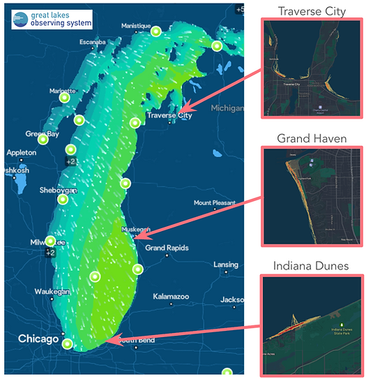
Offshore buoys (dots) measure conditions miles from shore. The highlighted insets — where people swim — has no coverage.
WHY THE DATA DOESN'T EXIST
Traditional instrumentation doesn't go
where people go.
Fixed sensors are expensive to deploy, maintain, and retrieve. Research vessels provide snapshots. Offshore buoys measure conditions miles from shore. None of these approaches deliver the spatial and temporal coverage that nearshore safety requires — and none can keep pace with rapidly changing local conditions.
Infrastructure cost
A single moored buoy costs tens of thousands of dollars to deploy and maintain. Nearshore zones require dense networks to capture meaningful variability — networks that don't exist.
Dynamic conditions
Rip currents shift position within hours. Sandbars migrate. Water temperature stratifies and mixes unpredictably. Fixed-point measurements simply cannot capture this variability in space and time.
Local knowledge
Experienced lifeguards and swimmers carry invaluable observational knowledge — but it can't be aggregated, archived, or shared with a swimmer entering unfamiliar waters for the first time.
THE CONSEQUENCE
Decisions made without data are
guesses.
Every day, thousands of people enter nearshore waters armed with a weather forecast and intuition. But even experienced locals are sometimes caught off guard by conditions that no forecast predicted. Lifeguards close beaches after incidents, not before.
This is a solvable problem. The instruments needed to collect the data already exist. Millions of people already wear them into the water every day.
FOR SWIMMERS
No reliable way to assess actual conditions at a specific beach before entering the water — only broad forecasts based on offshore data.
FOR RESEARCHERS
Coastal models remain unvalidated in the nearshore zone — limiting predictive skill where it matters most for public safety.
FOR SAFETY ORGANIZATIONS
Visitors arrive without any understanding of local conditions. That knowledge gap is invisible until something goes wrong.